Published January 20, 2012 02:30AM
Where Locals Hike in Rocky Mountain National Park
'Huai-Ying Chin'
Rocky Mountain Park Day Hike
Sky Pond via Lake Haiyaha
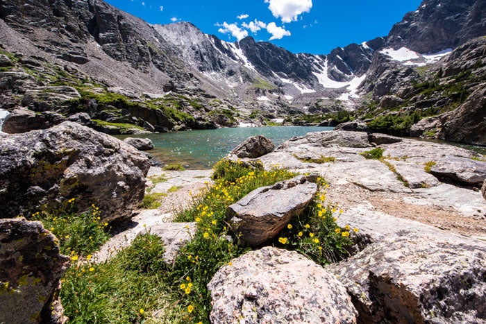
Seven lakes, two gorgeous waterfalls, and acres of columbine—this 10-miler packs in east-of-the-Divide delights. From Bear Lake, hike 1.1 miles to Dream Lake (passing Nymph Lake). Follow the Lake Haiyaha Trail to Glacier Knobs (lumps of rock). Take the Loch Vale Trail past the Loch, Timberline Falls and Glass Lake to Sky Pond, nestled below the Sharkstooth and Petit Grepon spires. Return to Glacier Knobs and continue down the Loch Vale Trail for two miles, past Alberta Falls, to reach a short traverse back to Bear Lake.


Weekend and Longer Hikes in Rocky Mountain National Park
Moraine Park to Bear Lake Loop
A wildlife-rich route with lakeside camping below glacial cirques, this trip follows the gentle Fern Lake Trail 1.8 miles to The Pool, then climbs south to campsites at Fern or Odessa Lakes (mile 4.8). Next morning, after admiring the sunrise lighting up Notchtop Mountain, continue south to a junction near Bear Lake. Head back northward past Mill Creek Basin and Steep Mountain for 3.9 miles, then bear right on Cub Lake Trail to return to Moraine Park, passing meadows where elk, mule deer, and coyote hang out.

Tonahutu Creek/North Inlet Loop
During the glacial ages, most of the snow that fell here built up on the east side, carving those rugged faces the crowds come to see. The west side is different: less jagged, with space to explore and full of sweet-smelling spruce. Starting near Grand Lake, this 21-miler includes half a dozen miles of tundra hiking along the spine of the Continental Divide. Weather permitting, drop your pack on the Divide and spend several extra hours rim-walking the eastern edge, staring down at near-thousand-foot walls and towers. This fantastic loop isn’t unknown, but you won’t be elbowed off the trail. The one thing you’ll compete for is a campsite just below timberline. The Renegade and July campsites are popular (reserve in advance). For more solitude, explore off-trail terrain, which you’ll share only with wildlife.
ADVERTISEMENT
The name is a crowd repellent, but snow actually melts out of the Never Summer Mountains in the northwest corner of the park as early as May. Then it’s open for backpackers to scramble its almost-13,000-foot peaks and marvel at a geographical anomaly: The Continental Divide loops southward here, and for about 6 miles, all east-flowing waters reach the Pacific and west-flowing waters head for Mississippi. The choicest weekend (or longer) loop goes up the Colorado River Trail and down the Grand Ditch Trail (10 to 15 miles round-trip). Each trail is unique: The former parallels the uppermost reaches of the stream that eventually carves the Grand Canyon; the latter follows an unused gravel road along a canal carrying water toward the parched eastern plains. Look closely, and you’ll find abandoned mines and the archeological remains of Lulu City, which once supported them. Little Yellowstone at the northern end recalls the bright white and yellow volcanic rocks of that famous Wyoming canyon.

Download an official Rocky Mountain National Park map for basic road and attraction locations. Want a detailed topographical map of trails in the park? Buy the National Geographic Trails Illustrated Map for Rocky Mountain National Park at REI.com. The map includes trails, trailheads, points of interest, campgrounds, lakes and much more. Or get the Trails Illustrated Rocky Mountain National Park Day Hikes map with 16 detail maps, trail mileages and difficulty ratings. Both maps are printed on waterproof, tear-resistant material.
If you buy from shopping links on this website, National Park Trips may receive an affiliate commission.