Updated July 1, 2024 08:36AM
Which Trail Should I Hike in Rocky Mountain National Park?
Find your perfect hiking trail in Rocky Mountain National Park by answering a few questions. Then view our personalized guide to the trail.

Sky Pond under the Cathedral Spires including Sharkstooth in Rocky Mountain National Park (Photo: Getty Images)
What do you most want to see at Rocky Mountain National Park? We’ve developed a short guide on some of the park’s best hiking trails based on the views.
Rememberm, timed-entry reservations are required for peak hours in the summer and early fall and are in addition to your entrance fee.
1. Elk and moose
Big Meadows is wildlife central
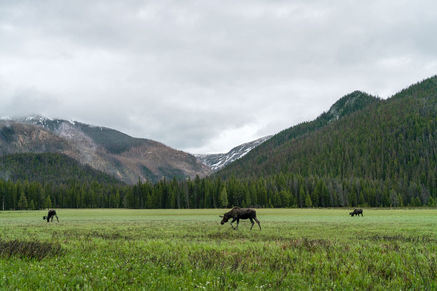
Elk can be spotted all over the park, but moose? You’ll have to head over to the wetter, cooler West Side for one of those. The huge ungulates are frequently seen munching on the marshy grasses in this expansive meadow—and elk are a good bet here, too. To get there, hike 1.8 easy miles from the Green Mountain trailhead through the lodgepole pine forest to reach Big Meadows, a wide, peaceful field tucked under 12,000-foot peaks.
2. High country above treeline
Ute Trail – 4 miles

It’s all tundra, all the time on this trail, which meanders across the park’s highest elevations. The trail has two segments— one that runs between the Alpine Visitor Center and Milner Pass, and another that connects the Ute Crossing Trailhead on Trail Ridge Road to Beaver Meadows. Top dayhike: the 4-mile (round-trip) from Ute Crossing to Timberline Pass, where you’ll earn uninterrupted vistas of Longs Peak and Moraine Park. Hike it early: There’s no shelter from summer thunderstorms up here.
ADVERTISEMENT
Longs Peak – 15 miles and steep

The squared-off top of 14,259-foot Longs Peak is the park’s (and arguably, Colorado’s) most coveted summit. The “easiest” route, the Keyhole Route, requires a 15-mile (round-trip) hike with more than 5,000 feet of elevation gain, a predawn start, and a strong stomach for exposure: The last mile of the trip is a vertiginous scramble over boulders and scree in a no-slip zone. But the view (and the bragging rights) from the top make it all worthwhile. This is an intense hike and should not be attempted unless you have previous high-alpine hiking experience. Read the ten most frequently asked questions about the Longs Peak hike.
3. A peaceful alpine stream.
East Inlet on the West Side

One of the West Side’s most scenic trails follows the East Inlet stream past gushing Adams Falls, meadows frequented by moose and beaver, postcard views of 12,007-foot Mt. Craig, and a series of peak-framed alpine lakes. Hike the whole trail 7.8 miles (one-way) to Spirit Lake, or make it a shorter hike by turning around at Lone Pine Lake (5.5 miles) or the open meadow around mile 1.5.
Lawn Lake on the East Side

Trace the Roaring River 6.2 miles to a large, trout-rich lake under several Thirteeners on this moderate trail. “Roaring” is right: In the 2013 flood, the river surged over its banks, destroying sections of trail. And during massive flooding in 1982, the Lawn Lake Dam burst, depositing a 40-acre debris field called the Alluvial Fan at the base of the river near the trailhead.
ADVERTISEMENT
4. A beautiful mountain lake
Gem Lake – 3 to 4 miles

This short-but-steep trail to Gem Lake (1.6 miles and 1,000 feet of elevation gain) climbs through the hulking boulders of Lumpy Ridge to a teacup lake with a small, sandy beach. You’ll earn fantastic views over Estes Park and across to Longs Peak on the way up.
Nymph Lake, Dream Lake and Emerald Lake – 3 to 4 miles

The heavily-traveled out-and-back Emerald Lake Trail passes three beautiful alpine lakes. Start from Bear Lake Trailhead, and begin a steady 0.5-mile ascent along a crumbling asphalt path to Nymph Lake. From there the trail becomes a ribbon of soft dirt crossing through a boulder field before reaching Dream Lake. If you have a wide-angle lens this is the lake to use it at. Even better, get here early to catch one of the park’s best sunrise photo opportunities. Continue a steady ascent to Emerald Lake, the final yet spectacular destination.
Sky Pond – 10 miles
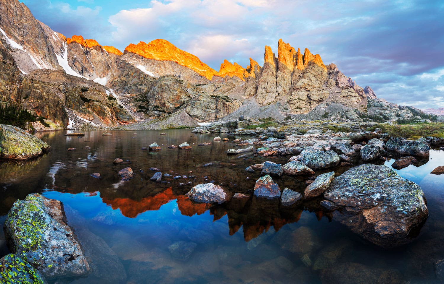
The alpine tarn of Sky Pond glittering beneath a series of toothy peaks boasts some of the park’s most dramatic scenery. On the difficult, 4.9-mile (one-way) hike from Glacier Gorge, you’ll also pass Alberta Falls, The Loch, and Lake of Glass and scramble up alongside 100-foot Timberline Falls.
ADVERTISEMENT
Download an official Rocky Mountain National Park map for basic road and attraction locations. Want a detailed topographical map of trails in the park? Buy the National Geographic Trails Illustrated Map for Rocky Mountain National Park at REI.com. The map includes trails, trailheads, points of interest, campgrounds, lakes and much more. Or get the Trails Illustrated Rocky Mountain National Park Day Hikes map with 16 detail maps, trail mileages and difficulty ratings. Both maps are printed on waterproof, tear-resistant material.