Published March 3, 2014 09:38PM
Mountain Strong - Rebuilding After the Flood of 2013
Witness the rebuilding and rebirth of local communities and the landscape itself after the 100-year flood of 2013.
'Wikimedia Commons Public Domain'
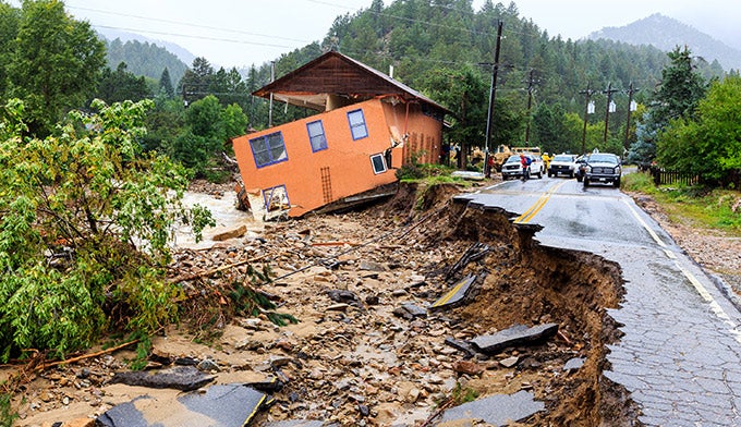
Last September 11, rain started to pound Colorado’s Front Range. What happened next became the stuff of 24-hour cable-news coverage: Raging floodwaters and mudslides destroyed roads and bridges, swamped cars and houses, and marooned entire towns. By the time the skies finally dried five days later, the event was declared a 100-year flood—and a national disaster.
The 2013 floods hit close to home for us, literally: MyRockyMountainPark.com’s headquarters are in Boulder, one of the towns hardest hit by the deluge. Our own flooded basements and waterlogged cars joined an overall damage total that included 337 destroyed buildings in Boulder County alone, 27 ruined state and federal roads, and, most tragically, eight lives lost. Other communities suffered even more. The waters shut down all major roads into Estes Park, isolating residents in a flood zone during prime tourist season. Just down the road, the homes and businesses in riverside Lyons were hit so hard, much of the town had to be evacuated.
But even with the staggering scope of the damage, bright spots began to shine through within days. Rocky Mountain National Park escaped major destruction despite absorbing 12 inches of rain in 24 hours. Courageous first responders and volunteers worked tirelessly to rescue stranded residents. Neighbors banded together to shovel mud out of each others’ living rooms and gave generously to flood relief. Crews worked overtime to rebuild roads and return citizens to their homes. The result? The park and the surrounding region are already fully open for business and ready to welcome travelers.
ADVERTISEMENT
As the region recovers, we’ll also gain a rare glimpse into the natural forces that shaped this unique place. As our own Jonathan Dorn puts it, “I can’t wait to get into the backcountry at Rocky Mountain and see how the landscape has changed. Usually, the resculpting we’ll see happens only eon by eon, with the slow friction of wind and moisture. But with this storm, we’ll see the equivalent of 20,000 years of microerosion in some places—and dramatic transformation elsewhere. While we grieve the loss of life and property, the adventurers in us relish the opportunity to tread on what will be, in many ways, virgin terrain.” This is truly a remarkable time to visit the park: On top of experiencing all of the region’s usual charms, visitors will witness the rebuilding and rebirth of local communities and the landscape itself. We’ll see you on the trails!

Update March, 2014
Conditions Inside RMNP:
The west side of the Park (Grand Lake side) is open to their normal seasonal status.
On the east side of the Park (Estes Park side), most Park roads have reopened to their normal seasonal status. Old Fall River Road will be closed throughout 2014. Endovalley Road is closed at the East Alluvial Fan parking area. On some east-side trails, there may be damage and bridges may be missing. The section of trail between the Finch Lake Junction and Calypso Cascades is closed.
Check Current Conditions at http://www.nps.gov/romo/planyourvisit/flood_alert.htm
Regional Road Closures:
As repair is done to roads, the following may reduce to one lane in small sections – US 36 Northbound / Southbound between Pinewood Springs and Estes Park (Milemarker 4-20), US 34 Eastbound / Westbound Loveland to Estes Park (Milemarker 66-66)
Check Current Local Closures at http://www.cotrip.org/home.htm
Check Colorado Highway Closures at http://www.coloradodot.info/travel/colorado-flood-highway-updates
Update April, 2014
The U.S. Department of Transportation has allocated $3.5 million to repair flood damage to Old Fall River Road and the Alluvial Fan area. Old Fall River Road will remain closed to traffic throughout 2014 however.